
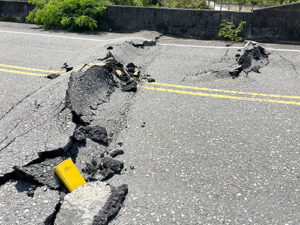
The September 17th Mw 6.5 and September 18th Mw 6.9 Taiwan earthquakes occurred within the Longitudinal Valley near the town of Chihshang in southeast Taiwan. These events ruptured components of a complex plate boundary accommodating approximately 40 mm/yr of oblique left lateral shortening. Both events nucleated along steeply west-dipping oblique left lateral structures associated with the Central Range fault but triggered displacements of up to 0.5 m or more on the adjacent, parallel, and oppositely dipping Longitudinal Valley fault. The LCI Research Program partially funded Principal Engineering Geologist Brian Gray’s participation in a one-week GEER reconnaissance to survey geologic and engineering effects of the earthquakes, which included surface rupture in Brian’s master’s thesis study area. As the fault rupture mapping team lead, Brian joined engineers from Oregon State University, Caltech, University of Michigan, University of British Columbia, University of Southern California, and University of California Berkeley, along with geologists and engineers from NCREE, Taiwan’s earthquake engineering research institute, to better understand the unique characteristics of triggered surface fault rupture from this sequence of damaging earthquakes.