
Supporting California’s Water Lifeline: LCI’s Role in Addressing Aqueduct Subsidence
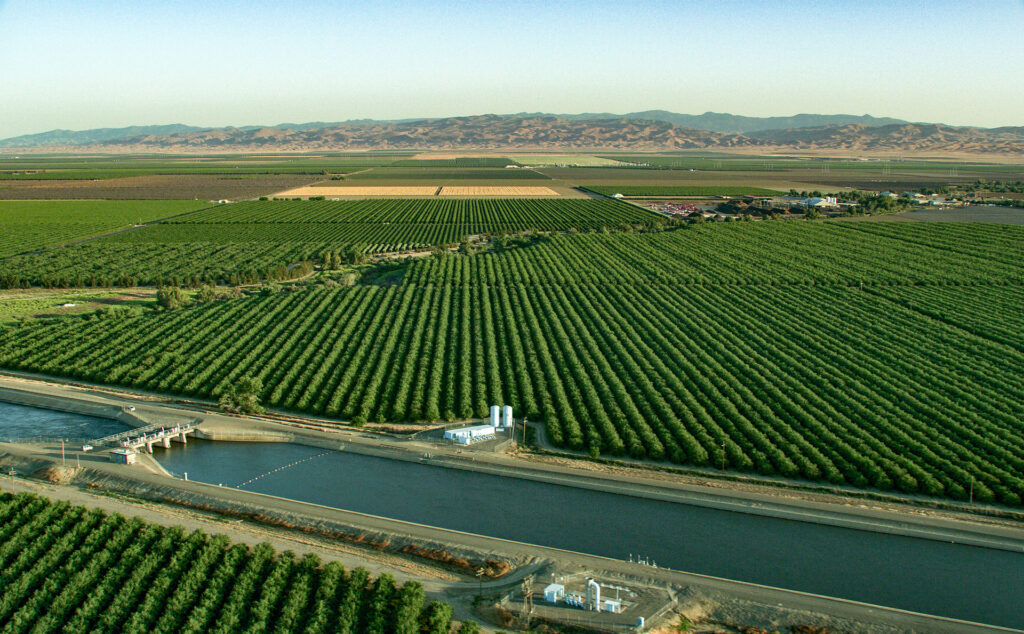
The California Aqueduct is a crucial part of the state’s water system, delivering water to 27 million people and irrigating vast agricultural lands. Yet this vital infrastructure faces a growing threat from land subsidence — the gradual sinking of the ground — which has been an ongoing issue in the San Joaquin Valley for nearly a century.
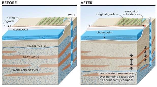
Before the Aqueduct was built in the 1960s, some areas near it had already dropped 20 to 30 feet. After construction, subsidence rates stabilized for a time, but in recent years, especially during the 2013–2016 drought, some sections sank nearly three feet, causing concern for the Aqueduct’s operation and longevity.
What Causes Subsidence?
Groundwater pumping, especially during droughts, is the primary cause. When surface water is scarce, farmers increasingly rely on groundwater, which lowers the water table and causes the land to compact and sink. Changes in agriculture — moving from row crops that can be fallowed during dry years to permanent orchards and vineyards requiring constant irrigation — have made this issue worse. Climate change is also expected to intensify drought conditions, putting more stress on groundwater resources.
Why Subsidence Matters for the Aqueduct
The Aqueduct moves water through a series of pools about 10 miles long, with small elevation drops of 2 to 4 feet used to keep water flowing. When land sinks unevenly, it changes these gradients, reducing flow capacity and making operations more challenging.
Subsidence can cause water to overflow protective liners, leading to erosion and damage to delivery structures. It also forces operators to pump water more often during peak electricity hours, raising energy costs. Given that the State Water Project is California’s largest electricity user, this has broader impacts on energy use statewide.
LCI’s Expertise in Action
The California Department of Water Resources (DWR) has launched a long-term program to understand and address subsidence. LCI has been a key partner since 2017, providing geologic and analytical support to help protect the Aqueduct.
LCI led the analysis of how land use changes and groundwater pumping have affected historic subsidence rates in the San Joaquin Valley. Using Geographic Information Systems (GIS), LCI mapped patterns of land use and processed data from hundreds of groundwater wells. This detailed analysis helped DWR identify where subsidence risks are highest and informed strategies to manage the problem.
LCI also developed methods to use precise survey data to forecast future subsidence and its uncertainties. This work was central to the 2019 Supplemental Report to the California Aqueduct Subsidence Study, which remains a foundational document for planning.
Forecasting and Planning for the Future
LCI led the developed of a probabilistic subsidence forecast model for the California Aqueduct Subsidence Program (CASP). This model incorporates climate projections, expected land use changes, and groundwater management policies under California’s Sustainable Groundwater Management Act (SGMA).
Developed as a SSHAC Level 2 study, the model integrates expert opinions on future scenarios, providing DWR with a robust tool to assess risks and evaluate potential mitigation measures. This probabilistic approach allows better preparation for multiple possible futures rather than relying on a single prediction.
Supporting Long-Term Resilience
Alongside forecasting, LCI supports related projects such as the California Aqueduct Subsidence Rehabilitation Project and the Recovery Feasibility Study. These efforts include assessing the No Action Alternative to understand the consequences of inaction on Aqueduct performance and maintenance costs.
By comparing these risks with potential rehabilitation options, DWR can make informed decisions about investments needed to ensure reliable water deliveries for decades to come.
LCI’s work with DWR exemplifies how science and geologic expertise can tackle complex infrastructure challenges. As California faces a future shaped by climate change and evolving water demands, LCI is proud to help safeguard the California Aqueduct—protecting a lifeline that supports millions of people and the state’s agricultural economy.