
Two recently published peer‑reviewed studies examine how system‑level perspectives and expanded hazard information may support more comprehensive seismic risk assessments for critical infrastructure such as dams, nuclear facilities, pipelines, and transportation systems. The research appears in Earthquake Spectra (EQS) and the International Journal of Critical Infrastructure Protection (IJCIP). The two publications form a coordinated body of work exploring how system‑level risk can differ from site‑specific assessments and how additional hazard information (e.g., vertical-component hazard curves, regional-risk disaggregation, and ground‑failure maps) may support infrastructure‑related analyses.
System‑Level Risk Perspectives
The IJCIP study evaluates how seismic risk estimates can change when shifting from individual‑asset assessments to regional or system‑level evaluations. Using numerical examples from gas transmission pipelines and highway bridges, the study reports:
- A repair threshold that appears unlikely for a single pipeline segment can be up to 180 times more likely to be exceeded when evaluated across a regional pipeline network.
- A traffic‑disruption threshold that seems rare for an individual bridge can be 50 times more likely to occur when assessed at the regional highway‑system scale.
These findings illustrate how interconnected infrastructure systems may experience different levels of risk than suggested by site‑specific evaluations alone.
Examples of Hazard Information Relevant to Infrastructure Applications
The open‑access EQS article explores several types of hazard information that may be useful for infrastructure‑related analyses. The study presents examples of additional hazard information that may complement products such as the U.S. Geological Survey’s National Seismic Hazard Model (NSHM), including:
- (Figure 1) Prototype hazard curves for the vertical component of ground motion, which are relevant for structures sensitive to vertical shaking.
- (Figure 2) Prototype disaggregation of regional‑scale risk, using stochastic event sets to illustrate how different earthquake scenarios contribute to risk.
- (Figure 3) Prototype maps of permanent ground displacement (PGD), which may help identify areas where ground failure could influence risk to buried lifelines.
The study discusses how these types of information may be useful for certain infrastructure‑related analyses.
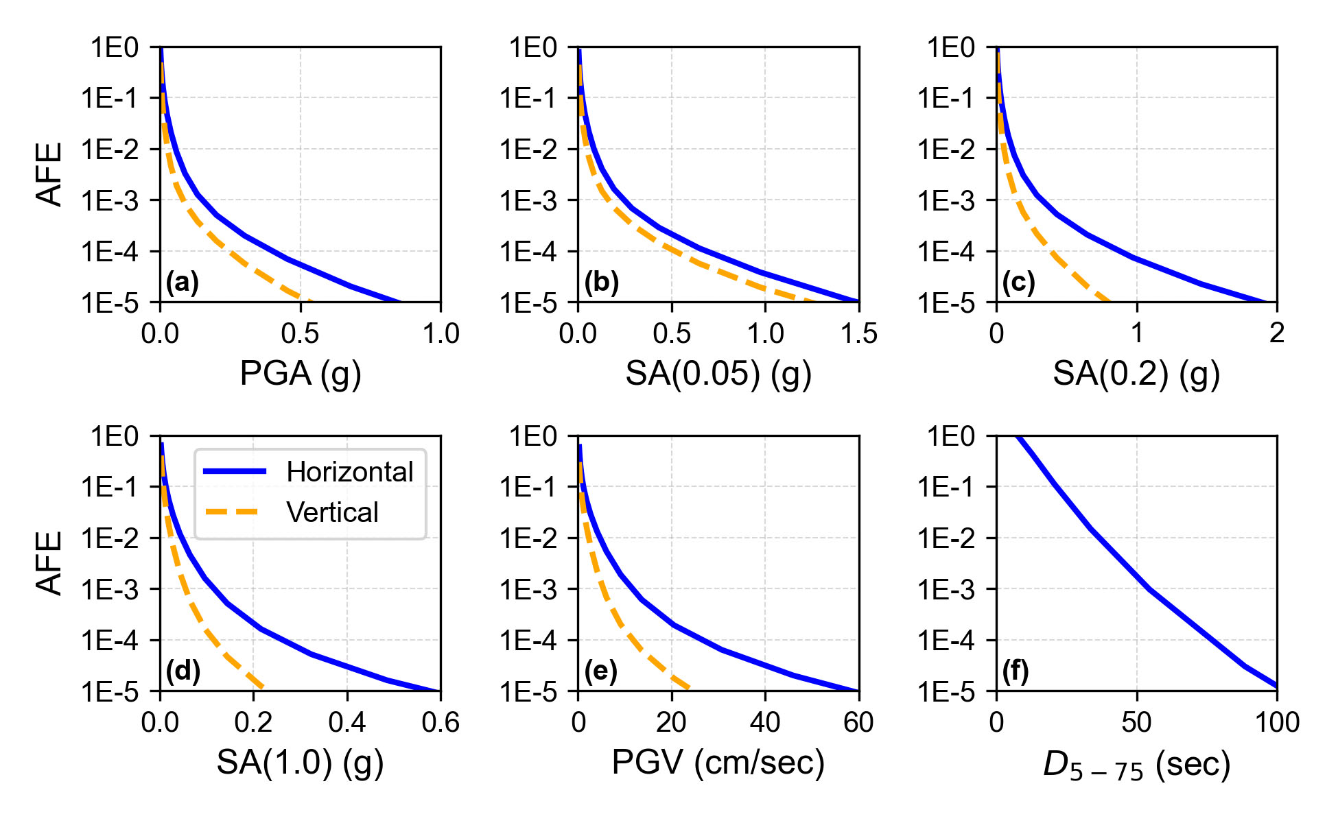
Figure 1. Prototype hazard curves for the vertical component of ground motion at Folsom Dam for select intensity measures: (a) peak ground acceleration (PGA), (b) 0.05-sec SA, (c) 0.2-sec SA, (d) 1-sec SA, (e) peak ground velocity (PGV), and (f) 5-75 significant duration; AFE: Annual Frequency of Exceedance; SA: Spectral acceleration.
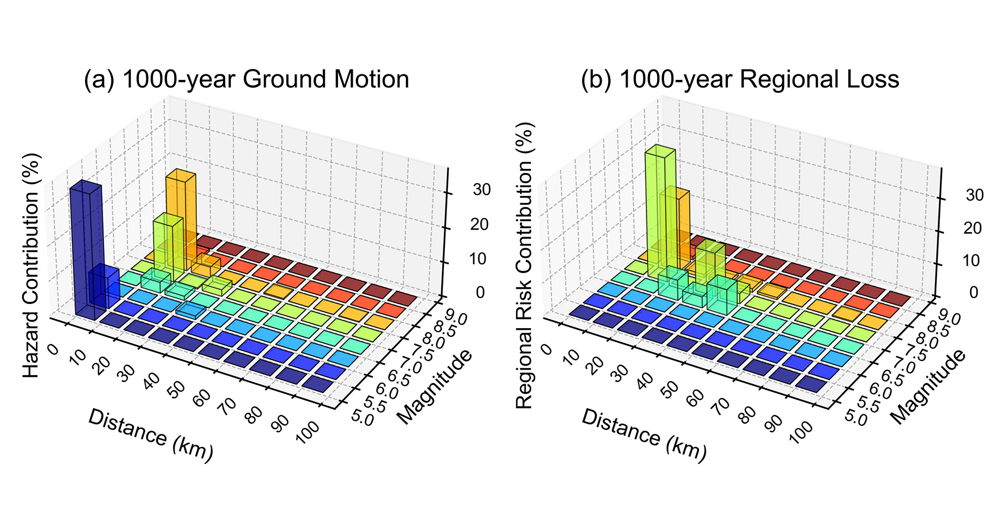
Figure 2. (a) Disaggregation of 1,000-yr ground motion; (b) prototype disaggregation of 1,000-yr regional loss from highway bridges in the San Francisco Bay Area.
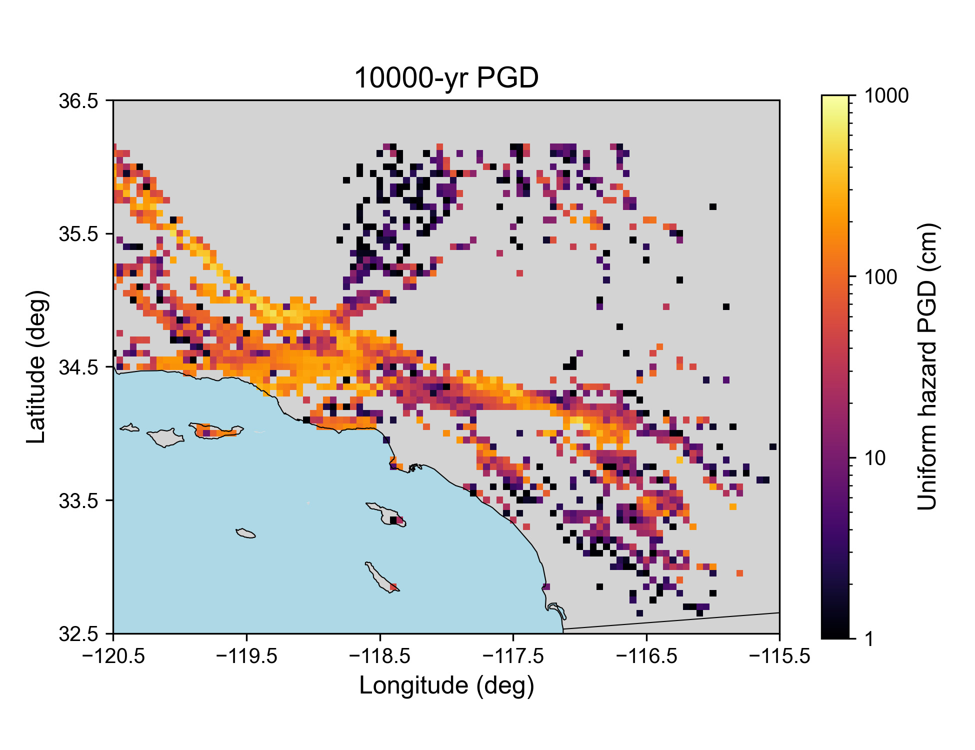
Figure 3. Prototype map of uniform-hazard permanent ground displacements (PGDs) in the Los Angeles region, using seismic-induced sliding displacements and a return period of 10,000 years.
Considerations for Stakeholders
The companion studies outline several considerations for organizations involved in infrastructure planning, hazard mitigation, or resilience assessment:
- System‑level evaluations may provide additional insight into how regional networks perform during earthquakes.
- Information such as hazard curves for the vertical component of ground motion, disaggregation of regional-scale risk, or maps of ground-failure metrics may support certain types of infrastructure analyses.
- Different forms of hazard information may be relevant depending on an organization’s planning, design, or risk‑management context.
These considerations reflect ongoing efforts within the scientific and engineering communities to understand and manage seismic risk across interconnected infrastructure systems.
About the Research
These publications reflect scientific research conducted by Dr. N. Simon Kwong, presently at Lettis Consultants International (LCI), and Dr. Kishor Jaiswal of U.S. Geological Survey (USGS). The research does not imply endorsement of any private organization or commercial product. Article availabe here.